Japan is one of the countries that have earthquakes most frequently in the world, and science and technology play a big role in protecting people's precious lives and property from earthquakes and making society safe.
With the present level of science and technology, it is impossible to prevent earthquakes from happening and also difficult to predict precisely when, where, and what size of earthquake would happen. However, for us who live in Japan, "to know about earthquakes" is a precondition to make preventive measures. From this viewpoint, based on the results of survey and observation research on earthquakes, a seismic hazard map was made, which shows predictions of earthquakes all over Japan, including their strength, from a long-term viewpoint. There is also a website from which you can get information such as the seismic hazard map of the area you wish to know about and the information used to make the map (J-SHIS, Japan Seismic Hazard Information Station http://www.j-shis.bosai.go.jp).
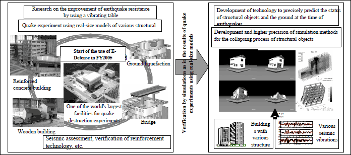
In the Hanshin-Awaji earthquake in 1995, about 6,400 precious lives were lost and the reasons over half of these were compression or suffocation by collapsed houses. Many public buildings, roads, and bridges received major damage as well. Based on this as a lesson, E-Defense, which is an ultra-large experiment apparatus that can actually shake various buildings of up to 1,200 tons on the scale of the Hanshin-Awaji earthquake, has been in operation from 2005 for verifying the earthquake-proof safety of buildings and examining reinforcement methods and earthquake-resistant buildings.
The development of a security system has been promoted, which can detect the primary wave (P wave) when an earthquake occurs and can, before the secondary wave (S wave) reaches, stop electricity, gas, factory production lines, elevators, etc., and announce urgent earthquake information to local governments, power plants, factories, and the people related to emergency medical care and others.
Furthermore, the development of a system to send image information of disasters site via satellite connection from a camera attached to a helmet, and a system to find victims who are trapped under collapsed buildings have been promoted for prompt handling after an earthquake occurrence.

Source:
Created by Ministry of Education, Culture, Sports, Science
and Technology
Contacts
Research and Coordination Division, Science and Technology Policy Bureau
(Research and Coordination Division, Science and Technology Policy Bureau)


